DMA sensor map
The Operational Visibility sensor map displays a region's District Metered Areas (DMAs) as color-coded geographical areas. The shape of each DMA area is based on the locations of the DMA's sensors. The color of each area is based on the performance of the DMA:
-
Blue (A). The performance is good. Further loss reduction may be uneconomic and careful analysis is needed to identify cost-effective improvements.
-
Green (B). The performance has potential for improvement. Consider pressure management, better active leakage control, and better maintenance.
-
Yellow (C). The performance is poor. Non-revenue water reduction efforts should be intensified, even if water is plentiful and inexpensive.
-
Red (D). The performance is bad. The utility is using resources inefficiently and non-revenue water reduction programs are imperative.
-
Gray. Represents a DMA with no active sensors.
The map's legend contains toggle switches to customize the map view.
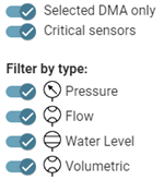
Note: Click a toggle switch to enable or disable that option. By default, all options are enabled.
The following toggle switches filter the overall map view:
-
Selected DMA only. The map displays only the selected DMA's sensors.
-
Critical sensors. The map displays only the critical sensors within the selected DMA or within all DMAs (if the Selected DMA only toggle switch is off). Critical sensor icons appear red.
The Filter by type toggle switches filter the types of sensors shown on the map:
-
Pressure
-
Flow
-
Water level
-
Volumetric
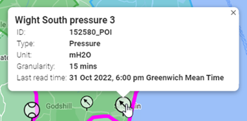
Hover over any sensor icon on the map to reveal a pop-up window with information about that sensor, including the sensor's name, ID, type, unit of measure, granularity, and last read time.
Click one or more sensor icons on the map to view their data in the chart beneath the map. Selected sensor icons appear larger. Click any selected sensor icons again to deselect the sensors and remove their data from the chart. For more information, see DMA sensor chart.
|
Tip: The standard Google Maps controls enable you to refine your view of the map:
|